
01
Geospatial Intelligence & Remote Sensing
We turn satellite, aerial, and drone imagery into clear, map-ready answers — what's there, what changed, and where to act. No more squinting at raw tiles or stitching reports by hand.
We build and deploy vision models and intelligent systems for organizations that need to turn imagery and sensor data into actionable insights and impactful solutions.
Each is delivered as a scoped project with defined outputs.
We turn satellite, aerial, and drone imagery into clear, map-ready answers — what's there, what changed, and where to act. No more squinting at raw tiles or stitching reports by hand.
Follow every object across frames and cameras.
We track objects, vehicles, and assets as they move through a scene and hand off between sensors — so you understand not just what's there, but where it came from and where it's headed.
We build systems that surface anomalies, risks, and threats from live imagery and sensor feeds — and alert the right people before a signal becomes an incident. Less noise, fewer misses.
Replace hours of manual image review.
Custom vision models that find, outline, and classify exactly what you care about — consistently, at scale, across photos and video. The accuracy of an expert, at the speed of software.
From a working model to a working system.
We design, train, and evaluate models against your own data, then put them into the system that will use them. You get benchmarks you can trust, a deployment path, and the monitoring to catch drift after launch.
Optimized models that deliver real-time results directly on drones, cameras, and embedded hardware — no cloud, no lag, no dropped connection. Built for the field, not the lab.
Gas transmission and gathering operators must know how many occupied buildings sit near every mile of pipe, and must re-check whenever development changes the answer. We automate that count. Our detection models find and outline every structure along your right-of-way in aerial, drone, or satellite imagery. We classify each one, compute the metrics your integrity program needs, and generate the reports.
Validated end to end on a pilot corridor: structure layer, class designations, and the study report.
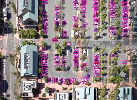
Georeferenced outlines of every building within the class location buffer, classified by occupancy and dated to the imagery.
Sliding-mile counts and Class 1 through 4 designations under 49 CFR 192.5. Potential impact radius and circle counts. High consequence area (HCA) and moderate consequence area (MCA) segments under 49 CFR 192.903 and 192.3. Identified sites. Change-in-class flags against your prior study.
Class location study reports ready for your 49 CFR 192.609 file, HCA and MCA segment tables in your GIS format, and a repeatable pipeline so annual re-studies run on new imagery.
Available as a one-time study, as an annual subscription with change detection against the prior survey, or as licensed software your team runs on its own imagery. We work from the imagery you already collect, or we source it: commercial satellite, drone, or contracted aerial flights, chosen per corridor.
You remain the operator of record. We give your integrity team the data and the documents to make and defend the determination.
We are here to assist you, from consulting to development. Let us know how we can help.